Delhi Faces Its Coldest Republic Day in Half a Decade
- Anjali Regmi
- Jan 27
- 5 min read

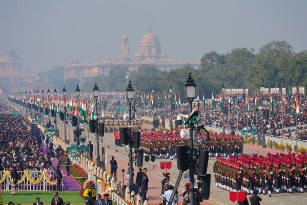
Delhi just wrapped up a historic Republic Day, but not just because of the parade and the celebrations. The national capital officially recorded its coldest January 26th in five years. While the city was draped in saffron, white, and green, residents were draped in heavy woolens and blankets to fight off a bone-chilling morning. The mercury took a significant tumble, leaving the city shivering even as the sun tried its best to break through the winter haze.
This sudden drop in temperature has caught many off guard. Just when people thought the worst of the winter was behind them, the northern winds decided to make a dramatic comeback. This cold snap has set a new benchmark for recent years, making it a talking point for everyone from morning walkers to commuters. If you felt that this year's parade was extra chilly, you weren't imagining it. The data confirms that the chill was indeed record-breaking for this specific day.
Breaking Down the Temperature Dip
The numbers coming in from the weather stations tell a clear story of an intense cold spell. Safdarjung, which serves as the base station for the city's weather, recorded a minimum temperature of 4.2°C. This is a massive four degrees below what is considered normal for this time of year. To put that in perspective, the last time Republic Day was this cold was back in 2021 when the temperature hit 2.1°C.
However, Safdarjung wasn't even the coldest spot in the city. Other areas felt the bite even more sharply. Ayanagar recorded a low of 3.6°C, while the Ridge area saw 5.3°C. These conditions met the official criteria for a cold wave in several pockets of the city. The combination of clear skies over the weekend and steady northwesterly winds allowed the heat to escape quickly at night, leading to these early morning plunges.
Rain is Knocking on the Door
While the cold was the headline yesterday, today's story is all about the clouds. The India Meteorological Department (IMD) has issued a yellow alert for today, January 27, 2026. This means we should prepare for a change in the atmosphere. A western disturbance is moving in, and it is expected to bring light to moderate rain across Delhi and the surrounding NCR regions.
Rain in late January usually brings a mix of relief and a different kind of chill. While the minimum temperature might actually rise slightly because of the cloud cover acting like a blanket, the lack of sun during the day will keep the maximum temperature low. The forecast suggests the high for today will hover between 18°C and 20°C. So, if you are heading out, keep that umbrella handy and maybe swap the light jacket for something waterproof.
Thunderstorms and Gusty Winds
It is not just going to be a quiet drizzle. The weather office has predicted that we might see isolated thunderstorms or even hailstorms in some parts of northwest India, including Delhi. Wind speeds are expected to pick up as well, reaching between 30 to 40 kmph. These gusty winds can make the outdoor air feel much sharper than the actual temperature suggests.
The shift from clear, freezing nights to cloudy, rainy days is typical of the western disturbances that frequent North India this time of year. These systems originate far away in the Mediterranean region and travel all the way to bring moisture and cold weather to our doorsteps. While it disrupts daily schedules and outdoor plans, it is a standard part of the winter cycle that helps maintain the region's climate balance.
The Impact on Air Quality
One silver lining to the predicted rain is the potential improvement in air quality. Over the Republic Day weekend, Delhi’s Air Quality Index (AQI) had slipped back into the "poor" category, with readings around 241. This happened after a brief and rare stretch of "moderate" air earlier in the month. The cold, heavy air often traps pollutants close to the ground, making it harder to breathe for those with respiratory issues.
Rain acts as a natural scrubber for the atmosphere. When it pours, the water droplets catch dust and smoke particles, pulling them down to the earth and clearing the air. Experts believe that the showers expected today and tomorrow could bring the AQI back into the "moderate" range temporarily. While it isn't a permanent fix for the city's pollution woes, a few days of cleaner air is always a welcome change for residents.
Snowfall in the Mountains
While Delhi deals with rain and wind, the mountains to the north are getting a heavy dose of winter magic. The same weather system is expected to bring significant snowfall to the Western Himalayan region. This includes places like Jammu and Kashmir, Himachal Pradesh, and Uttarakhand. For the plains, this usually means that once the clouds clear, the winds blowing from those snow-clad peaks will bring another wave of cold.
The connection between the hills and the plains is very direct during these months. Every time there is a heavy snowfall up north, Delhiites can expect the "Chilla-i-Kalan" vibes to intensify shortly after. For now, the focus remains on the immediate wet spell, but the long-term outlook suggests that winter is not quite ready to pack its bags and leave just yet.
Staying Safe and Warm
With the yellow alert in place, it is a good time to be a bit more cautious. Wet roads combined with the typical morning fog can make driving conditions tricky. If you are a commuter, leaving a few minutes early and maintaining a safe distance from other vehicles is a smart move. The sudden shift from dry cold to damp weather can also lead to seasonal flu and colds, so keeping warm and hydrated is essential.
For those who enjoy the winter, this is perhaps the peak of the season. The combination of a record-breaking cold day followed by winter rains creates a unique atmosphere that defines the northern Indian winter. Whether you are enjoying a hot cup of tea at home or navigating the rain-slicked streets, there is no denying that the weather is the main character in Delhi right now.
What to Expect for the Rest of the Week
The rain is likely to persist through Wednesday, January 28. After that, the clouds are expected to clear up by Thursday. However, don't expect a heatwave immediately. Once the rain stops and the skies clear, the minimum temperatures might dip again. The humidity levels will remain high, and we might see the return of moderate fog during the early morning hours.
By the weekend, the sun should be back in full force, and we might see a gradual rise in temperatures. But for the next 48 hours, the city is under the influence of the Western Disturbance. It is a time for umbrellas, raincoats, and perhaps staying indoors if you have the choice. Delhi’s weather is nothing if not unpredictable, and this week is proving to be one of the most eventful ones of the season.
The city has shown its resilience through the coldest Republic Day in half a decade. Now, it prepares to wash away the dust with the first significant rains of the year. As we move through the rest of January, the weather remains a constant reminder of the power and variety of the Indian winter season.


Comments